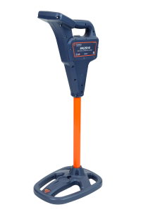
EML150 Electronic Marker Locator

Catalog Number: EML150
Locate, identify, map, and document buried utility markers with the Tempo EML150 Professional-Grade Electronic Marker Locator.

Designed for utility locating and maintenance professionals, the EML150 combines advanced electronic marker locating with Tempo’s Locator Link Mobile App, giving technicians a more intuitive and organized way to locate buried markers and build a digital record of their locations in the field.

The EML150 detects nine industry-standard electronic marker frequencies, making it suitable for locating markers used to identify underground utilities and infrastructure. Technicians can search for an individual marker frequency or use Scan Mode to search all enabled marker types simultaneously. When a marker is detected, the EML150 automatically identifies the marker type, giving technicians high-confidence identification of the buried utility below.

Locate and Document Buried Utility Markers
With the EML150’s Pin feature, technicians can geo-tag electronic markers and build a digital record of their locations that automatically syncs to the Locator Link Mobile App.

Within Locator Link, users can:

  • Capture GPS coordinates
  • Connect to external GNSS receivers for high-accuracy location data
  • View and organize marker locations
  • Add photos and field notes
  • Export location data for use with GIS and asset-management systems.

This connected workflow helps turn a marker locate into a usable digital record—without adding another clipboard to the truck.

Find it. Pin it. Document it.

Download the Locator Link App


The Next Evolution of Electronic Marker Locating The EML150 is a professional-grade electronic marker locator built for contractors, utility technicians, telecommunications professionals, municipalities, and infrastructure teams that need more than a basic marker locator. It provides a connected solution for locating, mapping, and documenting buried electronic markers, combining nine-frequency marker detection with Scan Mode, GPS-enabled marker records through Locator Link, external GNSS compatibility, and app-delivered software updates.

Designed for everyday field use, the EML150 features an easy-to-read color LCD screen, a replaceable rechargeable battery, and convenient USB-C charging with charger included.

Key Features

  • Detects nine industry-standard marker frequencies
  • Scan Mode simultaneously searches and identifies all enabled marker types
  • Pin feature records GPS coordinates of marker locations
  • Compatible with external GNSS receivers for high-accuracy location data
  • Syncs marker location records to the Locator Link Mobile App
  • Add photos and field notes to marker records in Locator Link before exporting to GIS
  • App-delivered software updates
  • Color LCD display
  • Rechargeable battery
  • USB-C charging

The EML150 gives utility professionals one connected tool for finding buried electronic markers and documenting exactly where they were found.

Locator Link App Features Map and Record Marker Locations Connect the EML150 to the Locator Link Mobile App to enable the Pin feature. Pinning a marker records its GPS coordinates and creates a marker location record in the EML150 that is immediately synced to Locator Link. Connect Locator Link to a compatible external GNSS receiver for high-accuracy location data.

Organize and Review Marker Records Marker records can be: Viewed in List or Map View Filtered by marker type or date Imported from an EML locator or from Locator Link on another mobile device Supplemented with notes and photos Export Marker Data Export saved marker records for sharing, documentation, or integration with GIS and other asset-management systems:  File Format and Content KMZ: Marker data, coordinates, notes, and photos CSV: Marker data, coordinates, and notes JSON: Marker data, coordinates, and notes

Software Updates Locator Link provides software updates for the EML150, allowing software improvements and updates to be installed without replacing the locator.

SpecificationEML150
ElectricalRechargeable Battery
Battery Life10 hours typical
ChargingUSB-C; charger included
Operating Temperature-4° to 122°F (-20°C to 50°C)
Storage Temperature-40° to 158°F (-40°C to 70°C)*
Ingress ProtectionIP65**
Length12.95 in (329 mm)
Width9.48 in (241 mm)
Height30.55 in (776 mm)
Weight5.05 lb (2.28 kg)

* Does not pertain to battery storage temperature limitations. See Instruction Manual for details.
** IP65 antenna housing / IP55 upper chassis. Independently tested to IEC 60529 standards for resistance to dust and water exposure.


ApplicationColorFrequency


Non-Potable WaterPurple66.4 kHz
Cable TVOrange/Black77.0 kHz
GasYellow83.0 kHz
Fiber OpticYellow/Black92.0 kHz
TelephoneOrange101.4 kHz
SantaryGreen121.6 kHz
Euro Power*Blue/Red134.0 kHz
WaterBlue145.7 kHz
Power*Red169.8 kHz

* 134 kHz Europower is only enabled in EU Mode, while 169.8 kHz Power is only enabled when EU Mode is off.


Passive Marker Detection Range

OmniMarker II / OmniMarker-ID* 5 ft (1.5 m)
Spike Marker / Spike Marker-ID* 3.3 ft (1 m)
*The EML150 detects ID markers but does not read or write ID marker data like the EML250-ID.


Available Accesories

Related Products